
Sir Creek: Where Geography Meets Geopolitics
“Behind the marshes of the Rann of Kutch lies a dispute that could redraw South Asia’s maritime map.”
Paromita Das
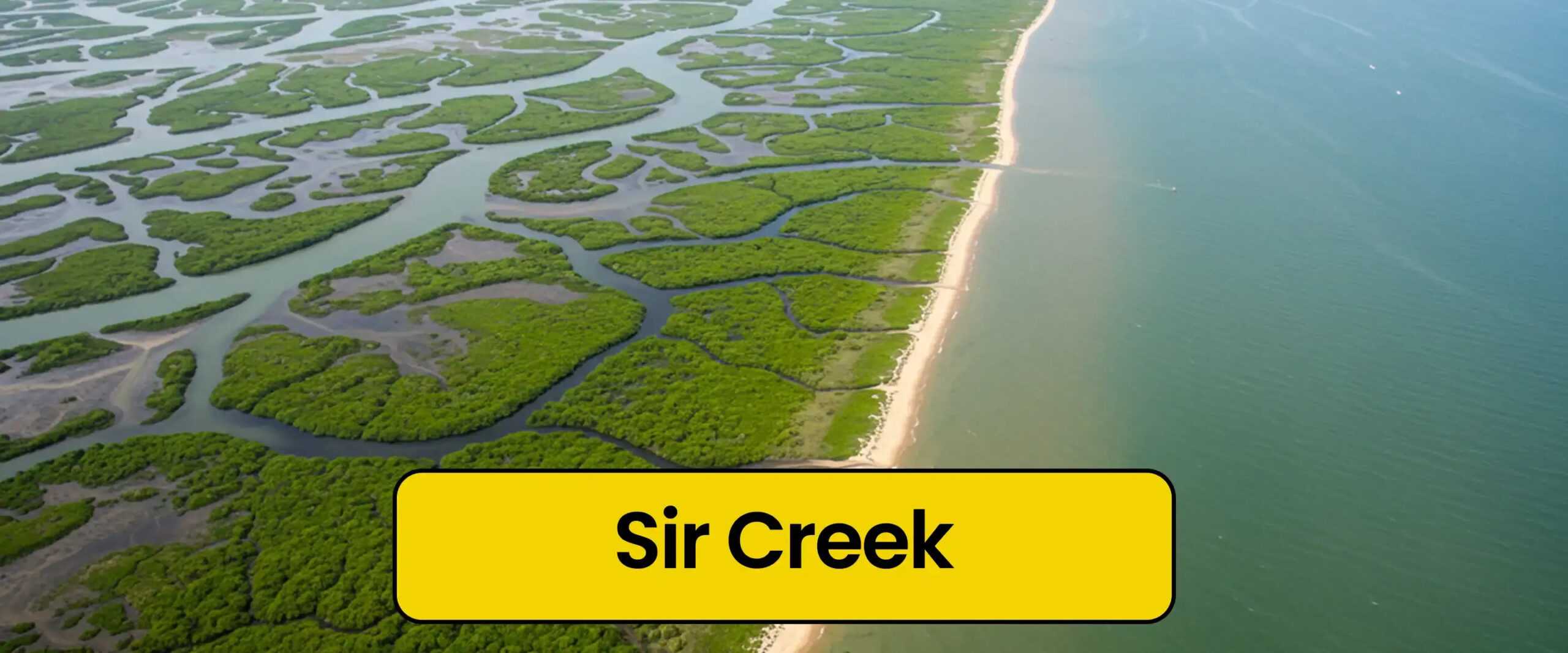
New Delhi, 21st October: At first glance, Sir Creek seems unremarkable—a narrow, swampy ribbon winding through the marshlands where Gujarat’s Rann of Kutch meets Pakistan’s Sindh province. Yet, beneath its calm tidal waters lies one of the subcontinent’s most complex geopolitical puzzles. Stretching about 96 kilometers, this estuarine channel is more than a geographical boundary—it’s a living metaphor for the entwined fates of Bharat and Pakistan, where cartography collides with national pride and strategic ambition.
Geopolitics often disguises itself in the mundane. What appears as a mere trickle of muddy water is, in reality, a potentially transformative frontier. As Lt. Gen. Satish Nambiar once observed, “Even a patch of sand or swamp can define the perimeter of national pride and security.” That sentiment perfectly encapsulates why this remote delta remains an emotional and strategic flashpoint for both nations.
A Colonial Legacy That Refuses to Fade

The roots of the Sir Creek dispute run deep into the colonial past. In 1914, British administrators attempted to demarcate the boundary between the princely state of Kutch and Sindh province. Two conflicting documents emerged: the 1914 resolution and the 1925 map.
Bharat bases its claim on the 1925 resolution, which places the entire creek within Bharatn territory. Pakistan, on the other hand, cites the 1914 version, arguing the border should follow the creek’s mid-channel. What began as a bureaucratic oversight evolved into a postcolonial boundary riddle, complicated by the shifting tides and sediments of the creek itself.
Why the Creek Matters: The High Stakes Beneath the Waterline
To the untrained eye, this may seem like a trivial cartographic quarrel. But geopolitically, Sir Creek defines where the land boundary ends and the sea boundary begins—a starting point that determines the extent of a nation’s Exclusive Economic Zone (EEZ) under the 1982 UN Convention on the Law of the Sea (UNCLOS).
If Bharat’s claim were accepted, its maritime boundary would extend significantly westward, unlocking vast areas rich in oil, gas, and marine resources beneath the Arabian Sea. Conversely, Pakistan would lose access to potentially lucrative waters. Thus, Sir Creek represents not just a border dispute but a contest for billions in blue economy assets.
A Human Story Amid Diplomatic Deadlock

Beyond the grand strategies and satellite maps lies a quieter tragedy. Every year, hundreds of fishermen from both sides drift unknowingly across the invisible maritime line. Arrested as “foreign intruders,” they languish in jails while their families wait across the border for news that rarely comes.
These are the human casualties of an unresolved boundary—people whose livelihoods depend on the very waters that politics has divided. The dispute’s ambiguity fuels mistrust and pain, turning fishermen into unintended hostages of geopolitics.
The Ecological Undercurrent

Sir Creek also holds immense ecological significance. It forms part of the fragile Indus Delta-Rann of Kutch ecosystem, home to mangroves, migratory birds, and endangered marine life. Rising sea levels and sedimentation have already altered the creek’s hydrology. Saline discharge from Pakistan’s Left Bank Outfall Drain adds further stress, threatening biodiversity on both sides.
Ironically, even amid their rivalry, Bharat and Pakistan share a common environmental interest. Collaborative conservation of this delta could yield enormous ecological dividends, strengthening coastal resilience against cyclones and climate change.
A Strategic Chessboard on the Western Frontier

For Bharat, Sir Creek is not merely a marshy estuary—it’s a strategic buffer zone guarding the western coast. The terrain’s complexity makes infiltration by sea difficult to monitor, yet potentially exploitable. Over time, Bharat has established border outposts, radar systems, and surveillance grids in the Kutch region to secure this sensitive frontier.
Pakistan, meanwhile, views any Bharatiya advantage here as a direct threat to its coastal security, especially with its economic lifeline—Karachi Port—lying just a few hundred kilometers away. Thus, Sir Creek has evolved into a microcosm of South Asia’s broader security dilemma, where defensive moves on one side appear offensive to the other.
The Diplomatic Stalemate

Despite decades of dialogue, Sir Creek remains unresolved. The 1965 Indo-Pak tribunal settled most of the Rann of Kutch dispute but deliberately left Sir Creek outside its purview. Later, both nations agreed under the Simla Agreement to resolve it bilaterally—excluding third-party arbitration.
Several rounds of technical and hydrographic talks have taken place, yet political will remains elusive. For both nations, conceding ground—literally or symbolically—is politically risky. The creek has become a test of national resolve, not just of maritime mapping.
Shared Waters, Divided Futures

In an age defined by energy security and climate urgency, Sir Creek could serve as a template for cooperation rather than conflict. Joint management of fisheries, hydrographic surveys, and ecological preservation could transform this disputed estuary into a zone of shared prosperity.
However, such optimism requires political maturity. Nationalism often blurs pragmatism, and as long as maritime sovereignty is equated with prestige, compromise will remain distant. Still, the logic of geography endures—both nations are bound by the same waters, winds, and weather.
A Missed Opportunity in the Making

The persistence of the Sir Creek dispute reflects the short-sightedness of South Asian geopolitics. Both Bharat and Pakistan invest heavily in military posturing, yet neglect the collaborative potential of maritime development. In an era when global powers are exploring joint blue economy ventures, South Asia’s inability to resolve a swamp-bound border seems increasingly anachronistic.
A cooperative framework here would not only secure marine resources but also signal diplomatic maturity—a gesture that could ripple across the subcontinent’s tense waters.
When Maps Shape Mindsets
Ultimately, Sir Creek is not about mud or marsh—it’s about memory, identity, and strategy. The 96-kilometre creek embodies the contradictions of the Bharat-Pakistan relationship: proximity without partnership, shared ecosystems without shared stewardship.
If ever resolved, Sir Creek could redefine not just a border but an entire mindset of mutual suspicion. Until then, it remains a quiet reminder that geography, though unmoving, continues to shape the destinies of nations.